World Trade Center

I flew to NYC for a presentation Monday evening by Ian Shapiro, co-author of Green Building Illustrated, which was recently published by Wiley. Sponsored by the Urban Green Council, the New York chapter of the U.S. Green Building Council, the author talk was held in the beautiful Trespa Design Centre in SOHO.

EPSON MFP image

Driving across the Manhattan Bridge from JFK with Ian that Monday morning, I confronted this distant view of the new WTC. Fortunately, I had some time to go back and capture that urban scene at the corner of Bowery and Canal Street.

EPSON MFP image

After meetings at Wiley the following day, I had some free time to walk around the WTC site, where I found this view of the WTC from the grounds of St. Paul’s Chapel.

International District

EPSON MFP image

For the monthly meeting of the Seattle Urban Sketchers group yesterday, we met in the International District of Seattle. I caught the bus downtown and as soon as I got off, I confronted this view of King Street Station with Century Link Field in the background and a maze of overhead wires in the foreground. I just had to draw it while standing under the awning in front of 308 4th Avenue South.

EPSON MFP image

Thinking about what to sketch in the ID district, I was convinced I had to document Kau Kau, which, as the sign on its awning says, is home of the best BBQ (char siu) in Seattle. So tender and juicy. You can see the effect of raindrops on the page.

EPSON MFP image

Finally, to get out the rain and damp cold, I joined a few others in the tea shop housed in the Panama Hotel. Designed by Japanese American architect Sabro Ozasa, who was a graduate of the University of Washington, the hotel opened in the summer of 1910 and was designated a National Historic Landmark in 2006. In the basement is the best surviving example of an urban-style Japanese bathhouse in the U.S.

St. Augustine

EPSON MFP image

Here are two sketches done during our recent trip south to St. Augustine, Florida. The first is of Flagler College, formerly the Hotel Ponce de Leon, which was designed by John Carrere and Thomas Hastings and built by Henry Flagler in the late 1880s. The original hotel was the first in Florida to be supplied with electricity and contains beautiful Tiffany windows. The view was drawn from the front arcaded walkway that helps define the entrance courtyard.

EPSON MFP image

This is the Plaza de Constitucion in St. Augustine, Florida, which was established by Spanish Royal Ordinances in 1573. After I began with the contours of the tree in the foreground, the drawing seemed to take on a life of its own, moving left toward the gazebo, and then to the right and ending with the 18th-century Cathedral Basilica in the background. It ended up as a two-dimensional graphic that relies more on overlap than linear perspective for depth.

Dungeness Ruins

After the workshops at the Savannah College of Art and Design, we drove south to Cumberland Island, Georgia’s largest barrier island, accessible only by ferry and now a designated National Seashore overseen by the National Park Service. At the southern tip of the island are the Dungeness Ruins, the remains of a mansion built by Thomas Carnegie, brother of Andrew Carnegie, and his wife Lucy in the 1880s as a winter retreat. This panoramic view of the site shows the open grounds, which looks southward over a vast saltwater marsh.

EPSON MFP image

While waiting for the ferry that would take us back to the mainland, I popped into the Ice House Museum and was excited to see a photograph of the mansion as it was before it burned in 1959. I quickly drew this view to show a little of its character in its heyday.

EPSON MFP image

Savannah

imageimageimage

We’ve spent the last few days in Savannah, Georgia, one of the largest National Historic Landmark Districts in the U.S. Savannah’s founder James Oglethorpe developed the original town plan on a grid centered around a series of squares. It’s instructive to see how the grid and series of park-like squares reveal themselves even today after all these years.

The purpose for our visit was to give a presentation and a series of workshops at the Savannah College of Art and Design. I’ll try to post a few drawings from the trip after our we return to Seattle. In the meantime, here are a few photos.

5th Urban Sketching Symposium

USk_Paraty

I am happy to announce that I have been selected to be among those who will be teaching workshops at the 5th International Urban Sketching Symposium to be held August 27–30, 2014 in Paraty, a historic Portuguese colonial town situated on the lush coastline between São Paulo and Rio de Janeiro. To be able to meet and draw with urban sketchers from all over the world in such a beautiful setting is a rare privilege.

For more information and to keep up with the latest news, see <http://paraty2014.urbansketchers.org>.

Seattle Bouldering Project

EPSON MFP image

The Seattle UrbanSketchers group met yesterday at the Seattle Bouldering Project, a climbing gym that offers a range of classes to introduce beginners to the sport as well as help more experienced climbers develop techniques for strong and skilled climbing. This view, which was drawn from the mezzanine level, began with blocking out the basic volume of the tall space. Then it was a matter of filling in with the climbing volumes and walls and pertinent details.

EPSON MFP image

Here is another view from below. Trying to capture the climbers themselves was difficult because of their constant movement so all you might be able to see are their ghost images.

The Indoor Sun Shoppe

IndoorSunShop

This is another in a continuing series of places in the Fremont neighborhood of Seattle. The Indoor Sun Shoppe opened its doors in 1970 in the University District but moved to its present location at 160 North Canal Street in Fremont in 2003. The shop sells greenhouse and indoor gardening supplies as well as a range of tropical and exotic houseplants, including Venus fly traps and other carnivorous plants. For inhabitants of Seattle and the Puget Sound region who have Seasonal Affective Disorder and the related blues because the winter daylight lasts only around nine hours, the Indoor Sun Shoppe also offers light therapy boxes!

Another View of Foreshortening

Print

Using the same broad outline of the Campo in Siena from two posts ago, I’ve overlaid the sketch with a diagram of the important points that I visualized in the scene—the extent of my view, the relative position of the Torre del Mangia, and the foreshortening of the Palazzo Pubblico.

CampPlanDiagram

To further illustrate the phenomenon of foreshortening, I’m using a plan diagram of the Campo to show where I stood as I sketched and my angle of view. You can compare the actual width of the Palazzo Pubblico, shown with the white arrow, with my foreshortened view of it, shown with the black arrow, and notice its position relative to the horizontal sweep of the Campo space.

You can also see, both in plan and in the perspective sketch, the positioning of the Torre about one-third of the way across from the right-hand edge of the view. I visualized diagonals to estimate the height of the Torre relative to the width of the space.

While these are necessarily optical judgments, not precise measurements, seeing these types of relationships and imagining them on the page as you set up a drawing on location are important steps in the process.

Foreshortening

Foreshortening

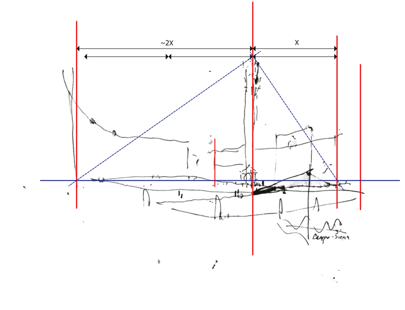
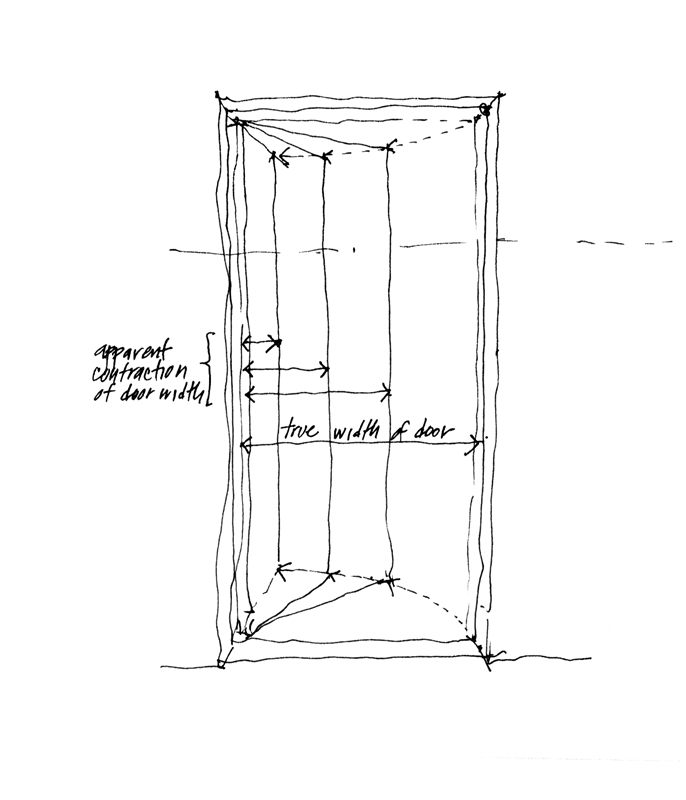
Foreshortening is the apparent change in form an object undergoes as it rotates away from our point of view. This phenomenon is usually seen as a contraction in size or length in the direction of depth, the amount of contraction depending on the degree of rotation. The more a line or plane is rotated away from our point of view, the greater its apparent contraction. You can easily see this as a door opens away from you. Gauging and drawing the phenomenon of foreshortening can be a bugaboo for sketchers because our mind can persuade us to draw what we know—the actual size or length of something—rather than how that thing might appear to the eye—its apparent size or length.

VirginiaV

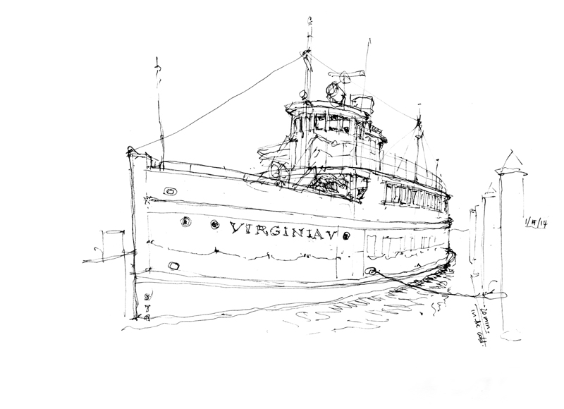
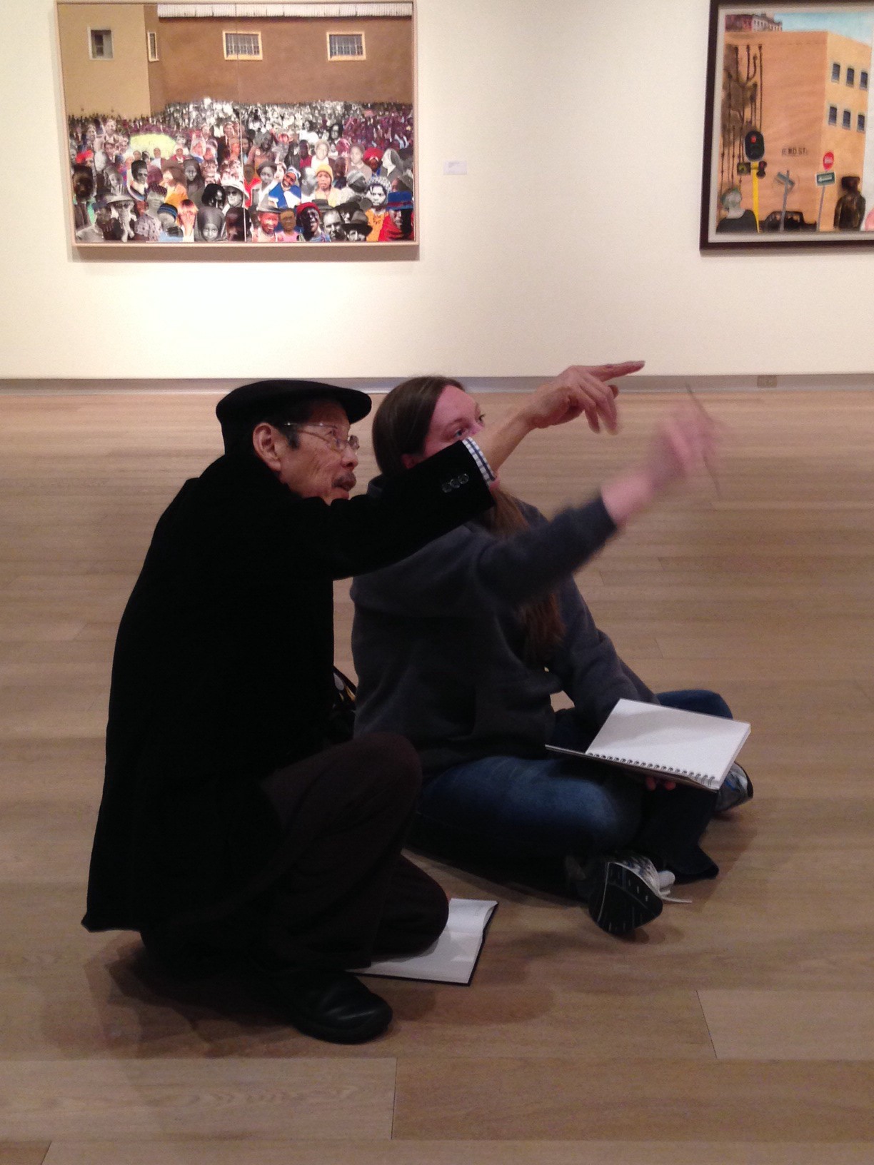
To illustrate a case of foreshortening I want to use this view of the Virginia V that I sketched this past Sunday before the Seattle UrbanSketchers group met at the Museum of History and Industry for its January meeting. One of the reasons for gathering at MOHAI is the beautiful exhibit there of Gabi Campanario’s impressive work documenting the life and times of Seattle over the past six years for the Seattle Times.

The Virginia V, built in 1921 by Anderson & Company and launched in 1922, was part of the mosquito fleet that plied the Puget Sound waters largely between the First and Second World Wars. After WWII, the Virginia V changed hands several times as it served as an excursion vessel. It was placed on the National Registry of Historic Sites in 1973. Completely refurbished by the Steamer Virginia V Foundation, the Virginia V is now anchored at the south end of Lake Union and continues to be used for public excursions and private charters.

Print

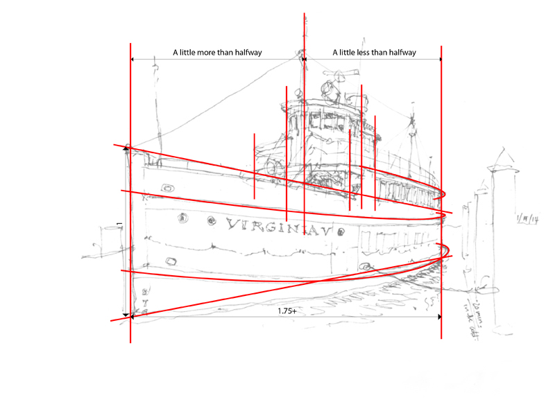
In this view of the same Virginia V sketch, I’ve overlaid some markers to show the relationships that I gauged and used to control the foreshortening of the ship. The most important step is ensuring that the apparent length—from the prow on the left to where the hull curves away from our view on the right—is correctly foreshortened relative to the height of the prow. Then, I positioned elements, such as the wheelhouse and bridge, relative to the left and right extents. Note how I try to suggest the way the hull is curved from fore to aft. You can use the span of your hand, the shaft of your pen or pencil, or any similar means to gauge these measurements but it is an essential step in the process. Otherwise, your mind will strongly suggest that you should draw what you know rather than how it appears to the eye.