An Alley View

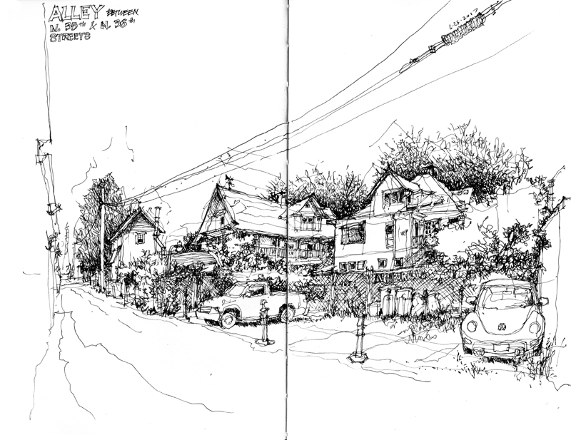
The Seattle Urban Sketchers group met at the Lenin stature in the Fremont neighborhood this past Sunday morning. Despite the, for Seattle, hot sun and extremely warm temperature, I managed to find a shady spot from which to draw this view along the alley between North 35th and North 36th Streets.

Alleys are interesting places. In addition to serving as conduits for goods and services, they provide more intimate views of the back sides of buildings and other structures, which we mostly see from their more public fronts.

If you look closely, you will notice the stray lines that indicate my several attempts to get the building forms in proper proportion, relative to the width of the view. It’s important to realize that it is extremely difficult to execute a drawing without any of these stray lines unless one draws first in pencil before inking over and erasing the pencil lines. I prefer using only ink and letting the process of building a drawing show through.

Place du Grand 9 Avril 1947

This is a view of Place du Grand 9 Avril 1947, also known as Grand Socco (Big Square), just outside one of the gates to the médina of Tangier. The square is named after the speech Mohmamed V gave in support of Moroccan independence on April 9, 1947. Normally the space is filled with street performers and vendors selling a variety of fruits, spices, and second-hand goods but it was somewhat quiet due to the beginning of the observance of Ramadan—the annual holy month of praying and fasting for Muslims worldwide

Médina Pathways

The Médina of Fès is one of the largest car-free urban zones in the world and through its pathways people and goods flow like the blood coursing through our arteries and veins. Because of their narrowness, it seems awkward to call these pathways “streets” although that is how they function. In addition to serving as paths for people and conduits for goods carried by handcart or donkey, these “streets” serve as informal social spaces and as extensions of small commercial establishments.

There are generally three scales, ranging from main streets as seen in the first image above, to side streets, and finally to back streets as narrow as a meter wide as seen in the images below.

Matters of Scale

This post is not about drawing. Rather, it concerns the issue of scale—the relative sizes of things and how we perceive this comparison—which is relevant to both drawing and design.

The historic core of the Médina of Fès, Fes el Bali, was founded in the late 9th century as the capital of the Idrisid Dynasty. The médina is full of souks and artisans working in leather, copper, brass, wood, textiles, and ceramics, and is home to historic mosques, mausoleums, and madrasas, as well as Al-Karaouine, founded in 859 and considered to be the oldest continuously operating university in the world. Markets line its car-free streets and sell all manner of herbs, spices, fruits, and vegetables. Declared a UNESCO World Heritage Site in 1981, the Médina of Fès remains to this day a medieval town in layout and scale, with a dense, low-rise building fabric, and narrow streets.

Returning home to Seattle from Fès, I find it difficult to convey the differences in scale and density of the two urban environments. Above, I overlaid (I hope accurately) the plan of the Médina of Fès atop a map of a portion of Seattle to indicate their relative sizes. What cannot be seen, however, are the relative population densities of the two urban areas. That of Seattle is around 6,800/square mile while that of the Médina is roughy 70,000/square mile. Even if my calculations are off by a little, that is a significant difference in scale that is difficult to understand without actually experiencing it.

Views of Morocco

Sharing a couple of views of Morocco. The first is a small court in the médina of Tangier. The second is a view from the rooftop of Riad Kettani, where we are staying in the médina of Fès. Entering médinas, especially the one in Fès, is like walking into new worlds.