Drawing for Lunch

Last week I met up with Frank Bettendorf, a fellow urban sketcher from Mount Vernon, and spent a few hours roaming around Fremont looking for sketching opportunities. While this was intended to be a sketching session, we ended up talking more about drawing rather than actually placing pen to paper. Frank B. had a lot of questions, and good ones too!

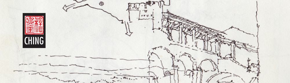
Having to explain my approach, the sequence in which I work, and how I make certain decisions along the way—all of these particulars made me realize how much I take for granted when I draw. It was useful to have to clarify and rationalize how I draw. Above is one of the sketches I used to explain my process.

I also recognize now that while many people might admire a finished drawing, the process by which it came to be can remain an inscrutable process, shrouded in mystery. Some of the keys I put forward are: composing the view by selecting an appropriate viewpoint; envisioning the scope of the drawing and placing it mentally on the page before laying down a line; starting strategically with a few key lines to establish the overall structure of the drawing; and thinking about how to convey the layers of spatial depth we see. This last point is probably the most important key: learning how to see.

And in exchange for spending a few delightful hours with Frank B., I got a free lunch at Tacos Guaymas! I look forward to more drawing sessions with Frank B.

Rome 2000

In the fall of 2000, I had the privilege of teaching in the University of Washington’s Architecture in Rome program. The scaffolding that normally covers many of Rome’s treasures for cleaning and restoration was nowhere to be seen. The Eternal City had been scrubbed and polished for the hosts of pilgrims traveling there for the Jubilee Year. Because I asked the students to keep a journal to record their quarter in Rome—on history walks, during field trips, and in the design studio—I felt obligated to do the same. And I am delighted I did. Looking back at my journals now brings back fond memories of the four times I taught there.

I remember telling the students that if a blank sketchbook was intimidating, skip a few pages, then go back and fill in the first few. Here are the first pages of my journal from 2000. The first shows the view out of my window in Apt. 6 in the Palazzo Pio, looking out onto Campo de Fiori.

The next two are sketches I did as I walked the streets and acquainted myself with the area before the students arrived and the quarter started. If you look carefully toward the bottom of each page, you will notice the very small plans  I used to remind myself of the context for the views I drew. I like to think of drawing on location not only as a mode of appreciation, but also a path to understanding and remembering.

Three Views of the Fremont Bridge

The Fremont Bridge opened in 1917 and continues to open about 30 times a day for boat traffic traversing the Ship Canal connecting Lake Union to the Puget Sound. In 1982 it was listed in the National Register of Historic Places along with the higher George Washington Memorial Bridge seen in the background. More commonly known as the Aurora Bridge, the steel cantilever-and-truss bridge carries State Route 99 across the west end of Lake Union.

This view is of the bridge as it serves as the south gateway to Fremont. The drawbridge is called a double-leaf bascule because it uses counterweights to continuously balance the two spans as they swing upward to provide clearance for the traffic passing beneath it.

Finally, we see the bridge from the Burke-Gilman Trail that passes beneath it on the north side of the Ship Canal. These three views remind us to evaluate our three-dimensional environments, especially the buildings and other artifacts of a city’s infrastructure, from different points of view.

Urban Hubs

Most major cities have one or more hubs where people gather because of the fortuitous mix of transport systems and civic, cultural, and commercial amenities. Here are views of three.

The first is of Shibuya, a center of shopping and nightlife located just outside one of Tokyo’s busiest railway stations. The bustling intersection is dominated by large video news and advertising screens and a sea of people using the “scramble” mode to cross in every direction at the same time while all vehicular traffic is stopped.

The second is of Times Square in the entertainment and Broadway theater district of midtown Manhattan. Again, the brightly lit environment is dominated by the gathering mass of people at ground level and the visual onslaught of oversized electronic billboards.

The third is of the Pike Place Market in Seattle. Though not of the scale of Shibuya and Times Square, this market entrance still serves as an iconic attraction for both Seattleites and visitors from abroad. In each case, it is not the architecture of individual buildings but rather the urban spaces created by the architecture and the overhead visuals that make these attractive urban hubs.

Bruge Rooftops


I’m resurrecting this from my Facebook posting of March 12, 2010, which has mysteriously vanished into the ether. This is a whimsical sheet that I composed in Bruges, Belgium, back in 1999. Being attracted to the variety of features that crowned the rooftop gables in the historic city center, I started the page with dotted lines to suggest a sheet of stamps. As I began, I also decided to incorporate numbers into the composition of each image, like the monetary values of postage stamps. An example of how we sometimes draw for the sheer enjoyment of the experience.

Carnegie Free Public Libraries

Andrew Carnegie (1835–1919) was a Scottish-American industrialist who devoted much of the later part of his life as a philanthropist, primarily through grants for the construction of over 2500 libraries in the United States and around the world. Carnegie believed in giving to the “industrious and ambitious; not those who need everything done for them, but those who, being most anxious and able to help themselves, deserve and will be benefited by help from others.” The first of the Carnegie libraries in the U.S. was built in 1889 in Braddock, Pennsylvania, home to one of Carnegie’s steel mills.

This Carnegie Free Public Library in Ballard was built in 1904 through a $15,000 grant provided by the Carnegie Library Program. Designed by Henderson Ryan, the Classic Revival structure featured radiating stacks, an auditorium, a men’s smoking room, and a women’s conversation room. The Ballard Chain Gang (!) did the landscaping under police supervision. When the city of Seattle annexed Ballard in 1907, the library became the first major branch of The Seattle Public Library.

The library was officially closed in June 1963 when a new, larger public library was built in the area. Since its closure, the library building has been used for a variety of private commercial enterprises. Seattle architect Larry E. Johnson nominated the library for recognition in 1976, and in 1979 it was listed on the National Register of Historic Places.

The Old Rainier Brewery

It’s now been twelve years since they stopped making beer at 3100 Airport Way South, the former home of Rainier Beer.

The brewing of beer in Seattle dates back to 1884, when Edward Sweeney established the Claussen-Sweeney Brewing Company in the Georgetown neighborhood of Seattle. After a series of mergers, Seattle Brewing and Malting Company emerged in 1893 and launched the Rainier brand of lager beer. The company ceased operations during the prohibition years and temporarily moved to San Francisco. After prohibition was repealed in 1933, however, the brewery re-emerged as the Rainier Brewing Company and relocated to this complex alongside the I-5 corridor south of downtown Seattle.

The iconic red neon R that used to stand atop the brewery is now in Seattle’s Museum of History and Industry, replaced by the green T when Tully’s was using the plant to roast coffee. The plant is now home to Tully’s headquarters, Bartholomew Winery, Red Soul Motorcycle Fabrications, a recording studio, and a number of artist lofts.

The Art of Urban Sketching

Monday evening, Gabi Campanario gave a talk at the University Bookstore about the history of Urban Sketchers and the publication of his new book, The Art of Urban Sketching, which was followed by a book signing. The book is a richly illustrated and inspiring compilation of the work of urban sketchers from over 50 cities around the world. Included are a lot of useful tips for drawing on location. Highly recommended.

Inspired by Paul Hogarth

Reaching back into the past, here is a view of Cleveland, Ohio, as seen from the Flats on the banks of the Cuyahoga River, which I drew during my year’s service in VISTA in 1972. I had originally posted this image on my Facebook fan page in February, 2010, but it is now apparently missing from my wall. At the time, I was fascinated with and inspired by the work of Paul Hogarth, noted English artist and illustrator, who used his drawings and watercolors to document places and events during his many travels, a reportage style of illustration that is now being kept alive through the work of Urban Sketchers <urbansketchers.org>.

The Fremont Troll

Another in a continuing series of drawings documenting sights in Fremont. Here, the Fremont Troll lurks beneath the north end of the Aurora Bridge, clutching a Volkswagen bug in the his left hand. The writing on the plaque that I copied beneath the sketch explains the Troll’s origin:

“The Fremont Troll was designed and built by Steve Badanes, Will Martin, Donna Walter and Ross Whitehead, with help from the community. The Fremont Arts Council sponsored the project, which hoped to build a greater sense of place in the neighborhood through art, and with it a stronger community…”

You can tell by the scratchy lettering it was much colder than I had realized when walking along North 36th Street to get to the site. There’s a lot of construction activity at this end of the bridge with the state seismically reinforcing the bridge supports, which I conveniently ignored.